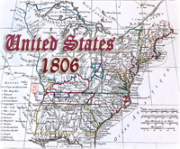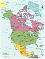
Historical Map of USA - Territorial Acquisitions
Between 1803 and 1898, the United States of America more than tripled its geographical size. Through purchase, compromise, and conflict, it became a continental nation with several noncontiguous possessions. This period of remarkable territorial expansion began with the opportunity to purchase Louisiana (2,144,520 square km) from France on April 30, 1803 for the bargain price.
In order to occupy the new territories in the first half of the 19th century, new settles, many immigrants from Europe, made their way to the West in wagons or on foot along one of many trails. Those desiring to establish farms in the fertile river valleys of Oregon country generally gathered in Independence, Missouri, before venturing forth in wagon trains across the expansive Great Plains and the formidable Rocky Mountains. Traffic on the California Trail increased significantly after the 1848 discovery of gold in California. Individuals interested in traveling from Missouri to areas in the Southwest generally followed the Santa Fe Trail.
Texas declared its independence from Mexico in 1836 and it was annexed by United States in 1845. This resulted in a two-year war between the United States and Mexico that ended with an US victory in 1848. The peace treaty gave the United States control of vast new territory extending to the Pacific Ocean.
Alaska was bought from Russia in 1867 and Hawaii was annexed in 1898.
|
Copyright © Geographic Guide - Maps World. United States of America. |
Source (edited): The National Atlas of the United States of America, U.S. Geological Survey, US Department of the Interior.