Map of South Chile
The southern Chile includes the Zona Sur and Zona Austral. The Chilean portion of Patagonia is part of the latter. The far south extends through the Chacao Channel to Cape Horn, the Andes and the South Pacific meet. The deeply indented coastline is filled with islands which preserve the general outline of the continent southward to the Fuegian archipelago, the outside groups forming a continuation of the Chilean Coast Range. The Cordillera of the Andes in Tierra del Fuego is formed of crystalline schists, and culminates in the snow-capped peaks of Mount Darwin and Monte Sarmiento in the Cordillera Darwin.
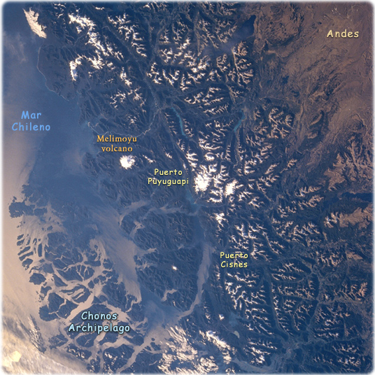
Chonos Archipelago, Chile February 1994. The rugged snow-capped Andes Mountains and the islands of the Chonos Archipelago can be seen in this view. Glaciers that formed during an ice age 12000 to 15000 years ago carved the u-shaped valleys in the region. The glacial process shaped the coast shown in this image, into fjords and coastal channels as sea levels rose with the melting of the ice fields. Chonos Archipelago is a series of low mountainous elongated islands with deep bays are traces of a drowned coastal range. Most of the islands are forested with little or no human settlement. Part of the remaining glacier that covered this portion of the Andes is discernible near the center of the image.
The deep Moraleda Channel separates the islands of the Chonos Archipelago from the mainland. The snow-covered Melimoyu volcano (2400 m) can also be seen.
|
Copyright © Geographic Guide - Maps World, American Continent. |
Chonos Archipelago

Map of South Chile